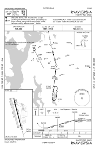
IAC chart of S43
 Satellite view of S43
Satellite view of S43
Sorry, we have no imagery here.
Sorry, we have no imagery here.
Sorry, we have no imagery here.
Sorry, we have no imagery here.
Sorry, we have no imagery here.


S43 - Harvey Fld
Located in Snohomish, United States
ICAO - S43, IATA -
Data provided by AirmateGeneral information
Coordinates: N47°54'18" W122°6'10"
Elevation is 23 feet MSL.
Magnetic variation is 17° East View others Airports in Washington
Operational data
Special qualification required
Current time UTC: 01:00:34
Current local time:
Weather at : KPAE - Seattle Paine Fld Intl ( 13 km )
METAR: KPAE 290053Z 36009KT 10SM CLR 18/11 A2989 RMK AO2 SLP119 T01830106
TAF: KPAE 282320Z 2900/2924 23010KT P6SM SKC FM290500 36007KT P6SM BKN050 OVC100 FM290700 18010KT P6SM OVC050 FM291200 17010KT P6SM -RA OVC020 FM291700 18010KT P6SM -SHRA OVC015
Communications frequencies: [VIEW]
Runways:
| RWY identifier | QFU | Length (ft) | Width (ft) | Surface | LDA (ft) |
| 15L | 165° | 2672 | 36 | ASPH | |
| 33R | 345° | 2672 | 36 | ASPH | |
| 15R | 165° | 2430 | 100 | GRASS | |
| 33L | 345° | 2430 | 100 | GRASS | |
| H1 | 0° | 0 | 0 | UNK |
Airport contact information
Address: Snohomish United States
