ADC chart of S31
 Satellite view of S31

Satellite view of S31
Sorry, we have no imagery here.
Sorry, we have no imagery here.
Sorry, we have no imagery here.
Sorry, we have no imagery here.
Sorry, we have no imagery here.


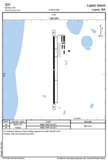
S31 - Lopez Island
Located in Lopez, United States
ICAO - S31, IATA - LPS
Data provided by AirmateGeneral information
Coordinates: N48°29'2" W122°56'16"
Elevation is 209 feet MSL.
Magnetic variation is 21° East View others Airports in Washington
Operational data
Special qualification required
Current time UTC: 02:34:27
Current local time:
Weather at : KFHR - Friday Harbor ( 8 km )
METAR: KFHR 260153Z AUTO VRB03KT 10SM OVC060 14/09 A2995 RMK AO2 SLP141 T01440089
Communications frequencies: [VIEW]
Runways:
| RWY identifier | QFU | Length (ft) | Width (ft) | Surface | LDA (ft) |
| 16 | 0° | 2905 | 61 | ASPH | |
| 34 | 0° | 2905 | 61 | ASPH |
Airport contact information
Address: Lopez United States
Satellite view of S31
Sorry, we have no imagery here.
Sorry, we have no imagery here.
Sorry, we have no imagery here.
Sorry, we have no imagery here.
Sorry, we have no imagery here.