ADC chart of S20
 Satellite view of S20

Satellite view of S20
Sorry, we have no imagery here.
Sorry, we have no imagery here.
Sorry, we have no imagery here.
Sorry, we have no imagery here.
Sorry, we have no imagery here.
Sorry, we have no imagery here.


S20 - Goldendale
Located in Goldendale, United States
ICAO - S20, IATA -
Data provided by AirmateGeneral information
Coordinates: N45°49'55" W120°50'43"
Elevation is 1678 feet MSL.
Magnetic variation is 19° East View others Airports in Washington
Operational data
Special qualification required
Current time UTC: 17:31:09
Current local time:
Weather at : KDLS - Columbia Gorge Rgnl/The Dalles Muni ( 34 km )
METAR: KDLS 251653Z AUTO 32017KT 10SM CLR 18/09 A2991 RMK AO2 PK WND 32028/1619 SLP128 T01830089
TAF: KDLS 251507Z 2515/2612 31011G17KT P6SM FEW150 FEW250 FM251800 32017G25KT P6SM SCT250 FM260100 30019G27KT P6SM BKN100 PROB30 2601/2606 -SHRA SCT070 OVC090
Communications frequencies: [VIEW]
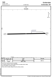
Runways:
| RWY identifier | QFU | Length (ft) | Width (ft) | Surface | LDA (ft) |
| 07 | 89° | 3491 | 40 | ASPH | |
| 25 | 269° | 3491 | 40 | ASPH |
Airport contact information
Address: Goldendale United States
Satellite view of S20
Sorry, we have no imagery here.
Sorry, we have no imagery here.
Sorry, we have no imagery here.
Sorry, we have no imagery here.
Sorry, we have no imagery here.
Sorry, we have no imagery here.