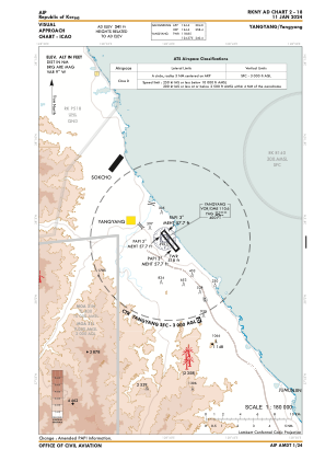
VAC chart of RKNY
 IAC chart of RKNY
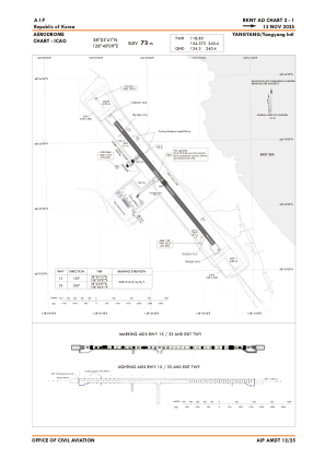
 ADC chart of RKNY
 Satellite view of RKNY

IAC chart of RKNYADC chart of RKNY
Satellite view of RKNY
Sorry, we have no imagery here.
Sorry, we have no imagery here.
Sorry, we have no imagery here.
Sorry, we have no imagery here.
Sorry, we have no imagery here.
Sorry, we have no imagery here.


RKNY - Yangyang / International
Located in Yangyang, Korea, Republic of
ICAO - RKNY, IATA - YNY
Data provided by AirmateGeneral information
Coordinates: N38°3'41" E128°40'9"
Elevation is 241 feet MSL.
Magnetic variation is -9° East View others Airports in Gang'weondo
Operational data
Special qualification required
Current time UTC: 12:54:56
Current local time:
Weather
METAR: RKNY 291200Z AUTO 17003KT 140V200 9999 ///011/// 15/13 Q1015
TAF: TAF RKNY 291100Z 2912/3018 15006KT 6000 FEW010 SCT020 TN13/2920Z TX20/3005Z BECMG 2913/2915 26006KT BECMG 2916/2918 35006KT 4000 BR BKN005 BECMG 2922/2924 04006KT 6000 NSW FEW010 BECMG 3001/3003 10006KT BECMG 3012/3014 26006KT
Communications frequencies: [VIEW]
Runways:
| RWY identifier | QFU | Length (ft) | Width (ft) | Surface | LDA (ft) |
| 15 | 141° | 8202 | 148 | CON | |
| 33 | 321° | 8202 | 148 | CON |
Airport contact information
Address: Yangyang Korea, Republic of
Satellite view of RKNY
Sorry, we have no imagery here.
Sorry, we have no imagery here.
Sorry, we have no imagery here.
Sorry, we have no imagery here.
Sorry, we have no imagery here.
Sorry, we have no imagery here.