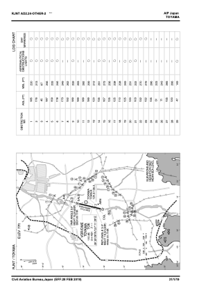
VAC chart of RJNT
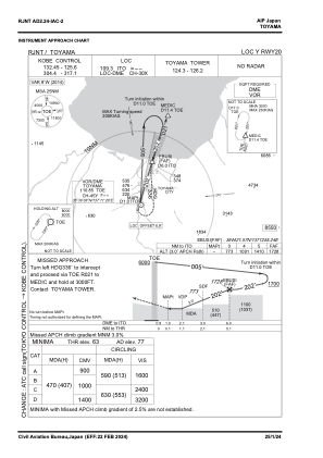
 IAC chart of RJNT
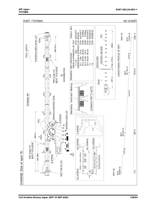
 ADC chart of RJNT
 Satellite view of RJNT

IAC chart of RJNTADC chart of RJNT
Satellite view of RJNT
Sorry, we have no imagery here.
Sorry, we have no imagery here.
Sorry, we have no imagery here.
Sorry, we have no imagery here.
Sorry, we have no imagery here.
Sorry, we have no imagery here.


RJNT - Toyama
Located in Toyama, Japan
ICAO - RJNT, IATA - TOY
Data provided by AirmateGeneral information
Coordinates: N36°38'54" E137°11'15"
Elevation is 77 feet MSL.
View others Airports in Toyama Prefecture
Operational data
Special qualification required
Current time UTC: 17:14:58
Current local time:
Weather
TAF: TAF RJNT 191105Z 1912/2018 20006KT 6000 -SHSN FEW012 BKN020 TEMPO 1912/1917 3000 -SHSN TEMPO 1917/2000 1500 -SHSN TEMPO 2000/2009 1500 -SHSN FEW003 BKN008 TEMPO 2009/2015 1500 -SHSN TEMPO 2015/2018 1500 -SHSN FEW003 BKN008
Communications frequencies: [VIEW]
Runways:
| RWY identifier | QFU | Length (ft) | Width (ft) | Surface | LDA (ft) |
| 02 | 14° | 6562 | 148 | ASP | |
| 20 | 194° | 6562 | 148 | ASP |
Airport contact information
Address: Toyama Japan
Satellite view of RJNT
Sorry, we have no imagery here.
Sorry, we have no imagery here.
Sorry, we have no imagery here.
Sorry, we have no imagery here.
Sorry, we have no imagery here.
Sorry, we have no imagery here.