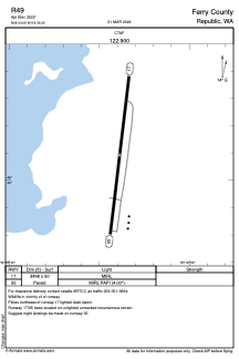
ADC chart of R49
 Satellite view of R49

Satellite view of R49
Sorry, we have no imagery here.
Sorry, we have no imagery here.
Sorry, we have no imagery here.
Sorry, we have no imagery here.
Sorry, we have no imagery here.
Sorry, we have no imagery here.


R49 - Ferry County
Located in Republic, United States
ICAO - R49, IATA -
Data provided by AirmateGeneral information
Coordinates: N48°43'6" W118°39'23"
Elevation is 2522 feet MSL.
Magnetic variation is 20° East View others Airports in Washington
Operational data
Special qualification required
Current time UTC: 18:34:59
Current local time:
Weather at : KOMK - Omak ( 69 km )
METAR: KOMK 291753Z AUTO 35008KT 10SM SCT110 22/14 A2993 RMK AO2 SLP128 60000 T02170144 10217 20156 51033
Communications frequencies: [VIEW]
Runways:
| RWY identifier | QFU | Length (ft) | Width (ft) | Surface | LDA (ft) |
| 17 | 0° | 3498 | 60 | ASPH | |
| 35 | 0° | 3498 | 60 | ASPH | |
| H1 | 0° | 0 | 0 | UNK | |
| H2 | 0° | 0 | 0 | UNK |
Airport contact information
Address: Republic United States
Satellite view of R49
Sorry, we have no imagery here.
Sorry, we have no imagery here.
Sorry, we have no imagery here.
Sorry, we have no imagery here.
Sorry, we have no imagery here.
Sorry, we have no imagery here.