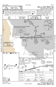
IAC chart of PHTO
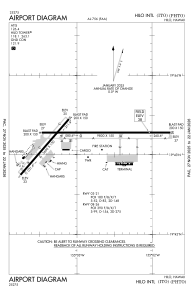
 ADC chart of PHTO
 Satellite view of PHTO

ADC chart of PHTO
Satellite view of PHTO
Sorry, we have no imagery here.
Sorry, we have no imagery here.
Sorry, we have no imagery here.
Sorry, we have no imagery here.
Sorry, we have no imagery here.
Sorry, we have no imagery here.


PHTO - Hilo Intl
Located in Hilo,
ICAO - ITO, IATA - ITO
Data provided by AirmateGeneral information
Coordinates: N19°43'13" W155°2'54"
Elevation is 38 feet MSL.
Magnetic variation is 11° East View others Airports in Hawaii
Operational data
Special qualification required
Current time UTC: 20:35:24
Current local time:
Weather
METAR: PHTO 221953Z VRB03KT 10SM FEW029 FEW044 BKN055 26/19 A3009 RMK AO2 SLP189 T02610194 $
TAF: PHTO 221737Z 2218/2318 24006KT P6SM VCSH SCT025 BKN050 FM222000 05009KT P6SM FEW025 BKN050 FM230500 24006KT P6SM VCSH SCT025 BKN050
Communications frequencies: [VIEW]
Runways:
| RWY identifier | QFU | Length (ft) | Width (ft) | Surface | LDA (ft) |
| 03 | 41° | 5600 | 150 | ASPH | 5251 |
| 21 | 221° | 5600 | 150 | ASPH | 5510 |
| 08 | 90° | 9800 | 150 | ASPH | 9800 |
| 26 | 270° | 9800 | 150 | ASPH | 9800 |
Airport contact information
Address: Hilo
Satellite view of PHTO
Sorry, we have no imagery here.
Sorry, we have no imagery here.
Sorry, we have no imagery here.
Sorry, we have no imagery here.
Sorry, we have no imagery here.
Sorry, we have no imagery here.