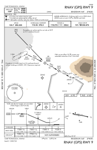
IAC chart of PHSF
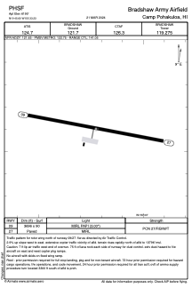
 ADC chart of PHSF
 Satellite view of PHSF

ADC chart of PHSF
Satellite view of PHSF
Sorry, we have no imagery here.
Sorry, we have no imagery here.
Sorry, we have no imagery here.
Sorry, we have no imagery here.
Sorry, we have no imagery here.
Sorry, we have no imagery here.


PHSF - Bradshaw Army Airfield
Located in Camp Pohakuloa,
ICAO - BSF, IATA - BSF
Data provided by AirmateGeneral information
Coordinates: N19°45'36" W155°33'14"
Elevation is 6190 feet MSL.
Magnetic variation is 10° East View others Airports in Hawaii
Operational data
Special qualification required
Current time UTC: 16:34:38
Current local time:
Weather
METAR: PHSF 241555Z AUTO 10007KT 10SM CLR 07/00 A3036 RMK AO2 SLP181 T00730000 $
Communications frequencies: [VIEW]
Runways:
| RWY identifier | QFU | Length (ft) | Width (ft) | Surface | LDA (ft) |
| 09 | 101° | 3696 | 90 | ASPH | |
| 27 | 281° | 3696 | 90 | ASPH |
Airport contact information
Address: Camp Pohakuloa
Satellite view of PHSF
Sorry, we have no imagery here.
Sorry, we have no imagery here.
Sorry, we have no imagery here.
Sorry, we have no imagery here.
Sorry, we have no imagery here.
Sorry, we have no imagery here.