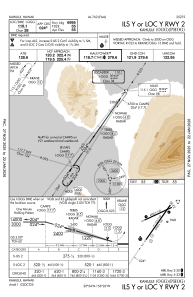
IAC chart of PHOG
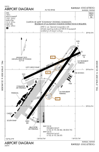
 ADC chart of PHOG
 Satellite view of PHOG

ADC chart of PHOG
Satellite view of PHOG
Sorry, we have no imagery here.
Sorry, we have no imagery here.
Sorry, we have no imagery here.
Sorry, we have no imagery here.
Sorry, we have no imagery here.
Sorry, we have no imagery here.


PHOG - Kahului
Located in Kahului,
ICAO - OGG, IATA - OGG
Data provided by AirmateGeneral information
Coordinates: N20°53'55" W156°25'50"
Elevation is 55 feet MSL.
Magnetic variation is 11° East View others Airports in Hawaii
Operational data
Special qualification required
Current time UTC: 19:37:47
Current local time:
Weather
METAR: PHOG 191854Z 05010G17KT 020V080 10SM FEW035 SCT065 27/17 A3007 RMK AO2 SLP188 T02720172
TAF: PHOG 191738Z 1918/2018 04008KT P6SM VCSH FEW030 SCT050 FM192000 05018G28KT P6SM FEW030 SCT050 FM200600 06009KT P6SM FEW030 SCT050
Communications frequencies: [VIEW]
Runways:
| RWY identifier | QFU | Length (ft) | Width (ft) | Surface | LDA (ft) |
| 02 | 35° | 6998 | 150 | ASPH | 6995 |
| 20 | 215° | 6998 | 150 | ASPH | 6995 |
| 05 | 65° | 4980 | 150 | ASPH | 4990 |
| 23 | 245° | 4980 | 150 | ASPH | 4990 |
| H1 | 0° | 0 | 0 | UNK |
Airport contact information
Address: Kahului
