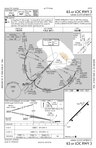
IAC chart of PHNY
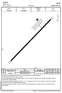
 ADC chart of PHNY
 Satellite view of PHNY

ADC chart of PHNY
Satellite view of PHNY
Sorry, we have no imagery here.
Sorry, we have no imagery here.
Sorry, we have no imagery here.
Sorry, we have no imagery here.
Sorry, we have no imagery here.


PHNY - Lanai
Located in Lanai City,
ICAO - LNY, IATA - LNY
Data provided by AirmateGeneral information
Coordinates: N20°47'8" W156°57'5"
Elevation is 1308 feet MSL.
Magnetic variation is 11° East View others Airports in Hawaii
Operational data
Special qualification required
Current time UTC: 18:14:00
Current local time:
Weather
METAR: PHNY 221756Z AUTO VRB05KT 10SM CLR 23/18 A3011 RMK AO2 SLP175 T02280178 10228 20178 53017
TAF: PHNY 221737Z 2218/2318 04008KT P6SM FEW015 FM222000 21006KT P6SM VCSH BKN025 FM230000 05017KT P6SM VCSH SCT025 BKN035 FM230800 05010KT P6SM FEW025 SCT035
Communications frequencies: [VIEW]
Runways:
| RWY identifier | QFU | Length (ft) | Width (ft) | Surface | LDA (ft) |
| 03 | 44° | 5001 | 150 | ASPH | 5000 |
| 21 | 224° | 5001 | 150 | ASPH | 5000 |
Airport contact information
Address: Lanai City
Satellite view of PHNY
Sorry, we have no imagery here.
Sorry, we have no imagery here.
Sorry, we have no imagery here.
Sorry, we have no imagery here.
Sorry, we have no imagery here.