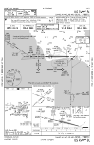
IAC chart of PHNL
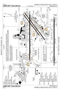
 ADC chart of PHNL
 Satellite view of PHNL

ADC chart of PHNL
Satellite view of PHNL
Sorry, we have no imagery here.
Sorry, we have no imagery here.
Sorry, we have no imagery here.
Sorry, we have no imagery here.
Sorry, we have no imagery here.
Sorry, we have no imagery here.


PHNL - Daniel K Inouye Intl
Located in Honolulu,
ICAO - HNL, IATA - HNL
Data provided by AirmateGeneral information
Coordinates: N21°19'4" W157°55'13"
Elevation is 14 feet MSL.
Magnetic variation is 11° East View others Airports in Hawaii
Operational data
Special qualification required
Current time UTC: 11:01:34
Current local time:
Weather
METAR: PHNL 211053Z 01004KT 10SM SCT090 24/19 A3002 RMK AO2 SLP164 T02390189 $
TAF: PHNL 210901Z 2109/2212 05008KT P6SM VCSH SCT025 SCT035 FM212000 05014G22KT P6SM FEW025 SCT045 FM220500 05010KT P6SM VCSH SCT025 SCT040
Communications frequencies: [VIEW]
Runways:
| RWY identifier | QFU | Length (ft) | Width (ft) | Surface | LDA (ft) |
| 04L | 53° | 6955 | 150 | ASPH | 6952 |
| 22R | 233° | 6955 | 150 | ASPH | 6952 |
| 04R | 53° | 9002 | 150 | ASPH | 8950 |
| 22L | 233° | 9002 | 150 | ASPH | 8937 |
| 04W | 51° | 3000 | 150 | WATER | |
| 22W | 231° | 3000 | 150 | WATER | |
| 08L | 89° | 12360 | 200 | ASPH | 12312 |
| 26R | 270° | 12360 | 200 | ASPH | 12300 |
| 08R | 90° | 12000 | 200 | ASPH | 12000 |
| 26L | 270° | 12000 | 200 | ASPH | 12000 |
| 08W | 91° | 5090 | 300 | WATER | |
| 26W | 271° | 5090 | 300 | WATER |
Airport contact information
Address: Honolulu
Other aviation service providers
Repair station

Flight schools

Mauna Loa Helicopters | Hawaii Pacific Aviation
Mauna Loa Helicopters | Hawaii Pacific Aviation
info@maunaloahelicopters.com8088346799