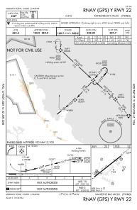
IAC chart of PHNG
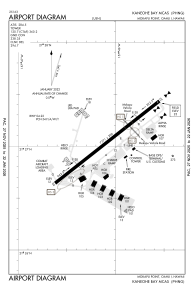
 ADC chart of PHNG
 Satellite view of PHNG

ADC chart of PHNG
Satellite view of PHNG
Sorry, we have no imagery here.
Sorry, we have no imagery here.
Sorry, we have no imagery here.
Sorry, we have no imagery here.
Sorry, we have no imagery here.
Sorry, we have no imagery here.


PHNG - Kaneohe Bay Mcas (Marion E Carl Fld)
Located in Kaneohe,
ICAO - NGF, IATA - NGF
Data provided by AirmateGeneral information
Coordinates: N21°27'2" W157°46'5"
Elevation is 23 feet MSL.
Magnetic variation is 10° East View others Airports in Hawaii
Operational data
Special qualification required
Current time UTC: 11:50:02
Current local time:
Communications frequencies: [VIEW]
Runways:
| RWY identifier | QFU | Length (ft) | Width (ft) | Surface | LDA (ft) |
| 04 | 52° | 7771 | 200 | ASPH | |
| 22 | 232° | 7771 | 200 | ASPH |
Airport contact information
Address: Kaneohe
Satellite view of PHNG
Sorry, we have no imagery here.
Sorry, we have no imagery here.
Sorry, we have no imagery here.
Sorry, we have no imagery here.
Sorry, we have no imagery here.
Sorry, we have no imagery here.