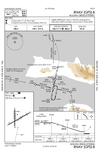
IAC chart of PHMK
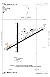
 ADC chart of PHMK
 Satellite view of PHMK
ADC chart of PHMK
Satellite view of PHMK
Sorry, we have no imagery here.
Sorry, we have no imagery here.
Sorry, we have no imagery here.
Sorry, we have no imagery here.
Sorry, we have no imagery here.
Sorry, we have no imagery here.


PHMK - Molokai
Located in Kaunakakai,
ICAO - MKK, IATA - MKK
Data provided by AirmateGeneral information
Coordinates: N21°9'10" W157°5'47"
Elevation is 454 feet MSL.
Magnetic variation is 11° East View others Airports in Hawaii
Operational data
Special qualification required
Current time UTC: 18:08:16
Current local time:
Weather
METAR: PHMK 201754Z 05010G27KT 10SM CLR 24/18 A3004 RMK AO2 PK WND 05027/1749 SLP174 60000 T02440183 10244 20217 53015
TAF: PHMK 201731Z 2018/2118 05011KT P6SM FEW035 SCT050 FM202000 05015G23KT P6SM FEW030 SCT040 FM210500 05010KT P6SM VCSH FEW025 SCT040
Communications frequencies: [VIEW]
Runways:
| RWY identifier | QFU | Length (ft) | Width (ft) | Surface | LDA (ft) |
| 05 | 60° | 4494 | 100 | ASPH | 4494 |
| 23 | 240° | 4494 | 100 | ASPH | 3901 |
| 17 | 180° | 3118 | 100 | ASPH | 2692 |
| 35 | 0° | 3118 | 100 | ASPH | 3118 |
Airport contact information
Address: Kaunakakai
Satellite view of PHMK
Sorry, we have no imagery here.
Sorry, we have no imagery here.
Sorry, we have no imagery here.
Sorry, we have no imagery here.
Sorry, we have no imagery here.
Sorry, we have no imagery here.