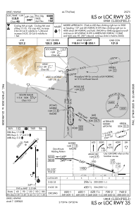
IAC chart of PHLI
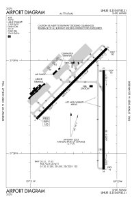
 ADC chart of PHLI
 Satellite view of PHLI

ADC chart of PHLI
Satellite view of PHLI
Sorry, we have no imagery here.
Sorry, we have no imagery here.
Sorry, we have no imagery here.
Sorry, we have no imagery here.
Sorry, we have no imagery here.
Sorry, we have no imagery here.


PHLI - Lihue
Located in Lihue,
ICAO - LIH, IATA - LIH
Data provided by AirmateGeneral information
Coordinates: N21°58'34" W159°20'20"
Elevation is 152 feet MSL.
Magnetic variation is 11° East View others Airports in Hawaii
Operational data
Special qualification required
Current time UTC: 19:35:21
Current local time:
Weather
METAR: PHLI 281853Z 07009KT 10SM CLR 26/18 A3011 RMK AO2 SLP192 T02610183
TAF: PHLI 281723Z 2818/2918 07010KT P6SM VCSH SCT025 BKN050 FM291200 30005KT P6SM FEW025 SCT050
Communications frequencies: [VIEW]
Runways:
| RWY identifier | QFU | Length (ft) | Width (ft) | Surface | LDA (ft) |
| 03 | 45° | 6500 | 150 | ASPH | 6500 |
| 21 | 225° | 6500 | 150 | ASPH | 6295 |
| 17 | 180° | 6500 | 150 | ASPH | 6500 |
| 35 | 360° | 6500 | 150 | ASPH | 6500 |
| H1 | 0° | 0 | 0 | UNK | |
| H2 | 0° | 0 | 0 | UNK | |
| H3 | 0° | 0 | 0 | UNK |
Airport contact information
Address: Lihue
