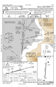
IAC chart of PHKO
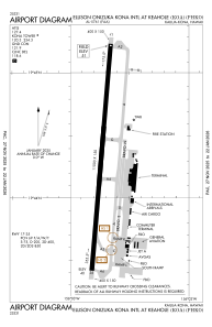
 ADC chart of PHKO
 Satellite view of PHKO
ADC chart of PHKO
Satellite view of PHKO
Sorry, we have no imagery here.
Sorry, we have no imagery here.
Sorry, we have no imagery here.
Sorry, we have no imagery here.
Sorry, we have no imagery here.
Sorry, we have no imagery here.


PHKO - Ellison Onizuka Kona Intl At Keahole
Located in Kailua/Kona,
ICAO - KOA, IATA - KOA
Data provided by AirmateGeneral information
Coordinates: N19°44'20" W156°2'44"
Elevation is 48 feet MSL.
Magnetic variation is 11° East View others Airports in Hawaii
Operational data
Special qualification required
Current time UTC: 20:02:27
Current local time:
Weather
METAR: PHKO 211953Z 20009KT 10SM BKN043 28/21 A3000 RMK AO2 SLP156 T02780206
TAF: PHKO 211735Z 2118/2218 13006KT P6SM FEW025 SCT050 FM211900 22010KT P6SM FEW035 SCT060 FM220400 20008KT P6SM VCSH SCT025 BKN035 FM220700 13007KT P6SM VCSH FEW025 BKN050
Communications frequencies: [VIEW]
Runways:
| RWY identifier | QFU | Length (ft) | Width (ft) | Surface | LDA (ft) |
| 17 | 185° | 11000 | 150 | ASPH | 11000 |
| 35 | 5° | 11000 | 150 | ASPH | 11000 |
Airport contact information
Address: Kailua/Kona
Other aviation service providers
Flight schools

Mauna Loa Helicopters | Hawaii Pacific Aviation
Mauna Loa Helicopters | Hawaii Pacific Aviation
info@maunaloahelicopters.com8083340234