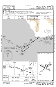
IAC chart of PHJR
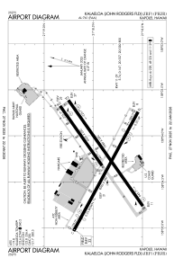
 ADC chart of PHJR
 Satellite view of PHJR

ADC chart of PHJR
Satellite view of PHJR
Sorry, we have no imagery here.
Sorry, we have no imagery here.
Sorry, we have no imagery here.
Sorry, we have no imagery here.
Sorry, we have no imagery here.
Sorry, we have no imagery here.


PHJR - Kalaeloa (John Rodgers Fld)
Located in Kapolei,
ICAO - JRF, IATA - JRF
Data provided by AirmateGeneral information
Coordinates: N21°18'26" W158°4'14"
Elevation is 32 feet MSL.
Magnetic variation is 11° East View others Airports in Hawaii
Operational data
Special qualification required
Current time UTC: 04:16:03
Current local time:
Weather
METAR: PHJR 200353Z 07007G24KT 4SM -RA FEW030 SCT038 BKN050 25/20 A3002 RMK AO2 RAE0255B49 SLP171 P0000 T02500200
TAF: PHJR 192325Z 2000/2024 07009G17KT P6SM BKN050 FM200500 05005KT P6SM FEW040 FM202000 07009G18KT P6SM BKN050
Communications frequencies: [VIEW]
Runways:
| RWY identifier | QFU | Length (ft) | Width (ft) | Surface | LDA (ft) |
| 04L | 55° | 4505 | 200 | ASPH | |
| 22R | 235° | 4505 | 200 | ASPH | |
| 04R | 55° | 7989 | 200 | ASPH | |
| 22L | 235° | 7989 | 200 | ASPH | |
| 11 | 118° | 8365 | 200 | ASPH | |
| 29 | 298° | 8365 | 200 | ASPH |
Airport contact information
Address: Kapolei
