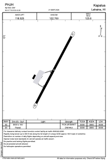
ADC chart of PHJH
 Satellite view of PHJH

Satellite view of PHJH
Sorry, we have no imagery here.
Sorry, we have no imagery here.
Sorry, we have no imagery here.
Sorry, we have no imagery here.
Sorry, we have no imagery here.
Sorry, we have no imagery here.


PHJH - Kapalua
Located in Lahaina,
ICAO - JHM, IATA - JHM
Data provided by AirmateGeneral information
Coordinates: N20°57'47" W156°40'23"
Elevation is 256 feet MSL.
Magnetic variation is 11° East View others Airports in Hawaii
Operational data
Special qualification required
Current time UTC: 09:44:39
Current local time:
Weather
TAF: PHJH 172338Z 1800/1824 07018G26KT P6SM VCSH SCT030 BKN050 FM180300 07009KT P6SM VCSH FEW030 SCT050
Communications frequencies: [VIEW]
Runways:
| RWY identifier | QFU | Length (ft) | Width (ft) | Surface | LDA (ft) |
| 02 | 28° | 3000 | 100 | ASPH | 3000 |
| 20 | 208° | 3000 | 100 | ASPH | 3000 |
Airport contact information
Address: Lahaina
Satellite view of PHJH
Sorry, we have no imagery here.
Sorry, we have no imagery here.
Sorry, we have no imagery here.
Sorry, we have no imagery here.
Sorry, we have no imagery here.
Sorry, we have no imagery here.