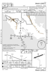
IAC chart of PHHI
 Satellite view of PHHI
Satellite view of PHHI
Sorry, we have no imagery here.
Sorry, we have no imagery here.
Sorry, we have no imagery here.
Sorry, we have no imagery here.
Sorry, we have no imagery here.
Sorry, we have no imagery here.


PHHI - Wheeler Aaf
Located in Wahiawa,
ICAO - HHI, IATA - HHI
Data provided by AirmateGeneral information
Coordinates: N21°28'53" W158°2'16"
Elevation is 843 feet MSL.
Magnetic variation is 11° East View others Airports in Hawaii
Operational data
Special qualification required
Current time UTC: 08:26:40
Current local time:
Weather
METAR: PHHI 220755Z AUTO 00000KT 10SM SCT026 SCT036 BKN043 BKN050 OVC080 22/19 A3007 RMK AO2 RAB0655E0658DZB0658E02DZB22E35 SLP173 P0000 T02170194 $
TAF: TAF PHHI 220800Z 2208/2314 VRB06KT 9999 SCT025 BKN035 QNH3007INS TEMPO 2208/2210 4800 -SHRA BR SCT007 BKN014 TEMPO 2210/2216 8000 -SHRA BR SCT006 BKN012 BECMG 2218/2219 07009KT 9999 SCT020 BKN030 QNH3006INS TEMPO 2220/2301 09012G20KT BECMG 2300/2301 VRB06KT 9999 SCT025 BKN035 QNH3005INS TX27/2223Z TN20/2215Z
Communications frequencies: [VIEW]
Runways:
| RWY identifier | QFU | Length (ft) | Width (ft) | Surface | LDA (ft) |
| 06 | 68° | 5608 | 100 | ASPH | |
| 24 | 248° | 5608 | 100 | ASPH |
Airport contact information
Address: Wahiawa
Satellite view of PHHI
Sorry, we have no imagery here.
Sorry, we have no imagery here.
Sorry, we have no imagery here.
Sorry, we have no imagery here.
Sorry, we have no imagery here.
Sorry, we have no imagery here.