ADC chart of PHDH
 Satellite view of PHDH

Satellite view of PHDH
Sorry, we have no imagery here.
Sorry, we have no imagery here.
Sorry, we have no imagery here.
Sorry, we have no imagery here.
Sorry, we have no imagery here.
Sorry, we have no imagery here.


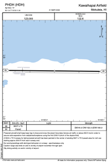
PHDH - Kawaihapai Airfield
Located in Mokuleia,
ICAO - HDH, IATA - HDH
Data provided by AirmateGeneral information
Coordinates: N21°34'46" W158°11'50"
Elevation is 14 feet MSL.
Magnetic variation is 11° East View others Airports in Hawaii
Operational data
Special qualification required
Current time UTC: 21:20:30
Current local time:
Weather at : PHHI - Wheeler Aaf ( 20 km )
METAR: PHHI 202115Z AUTO 07008KT 10SM BKN030 25/17 A3005 RMK AO2 SLP166 $
TAF: TAF PHHI 201600Z 2016/2122 VRB06KT 9999 FEW010 SCT020 BKN025 QNH3003INS TEMPO 2016/2020 8000 -SHRA SCT010 BKN020 BECMG 2019/2020 07009KT 9999 SCT030 BKN035 QNH2999INS TEMPO 2021/2103 06012G20KT BECMG 2103/2104 VRB06KT 9999 SCT020 BKN025 QNH3001INS TEMPO 2104/2110 6000 -RA BR SCT008 BKN020 TX26/2023Z TN19/2115Z
Communications frequencies: [VIEW]
Runways:
| RWY identifier | QFU | Length (ft) | Width (ft) | Surface | LDA (ft) |
| 08 | 91° | 9007 | 75 | ASPH | |
| 26 | 271° | 9007 | 75 | ASPH |
Airport contact information
Address: Mokuleia
