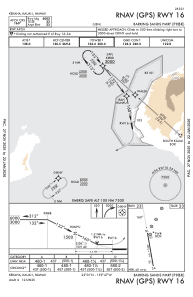
IAC chart of PHBK
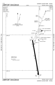
 ADC chart of PHBK
 Satellite view of PHBK

ADC chart of PHBK
Satellite view of PHBK
Sorry, we have no imagery here.
Sorry, we have no imagery here.
Sorry, we have no imagery here.
Sorry, we have no imagery here.
Sorry, we have no imagery here.
Sorry, we have no imagery here.


PHBK - Barking Sands Pmrf
Located in Kekaha,Kauai,
ICAO - BKH, IATA - BKH
Data provided by AirmateGeneral information
Coordinates: N22°1'22" W159°47'6"
Elevation is 23 feet MSL.
Magnetic variation is 10° East View others Airports in Hawaii
Operational data
Special qualification required
Current time UTC: 19:10:27
Current local time:
Weather
METAR: PHBK 211851Z AUTO 28005KT 10SM OVC090 27/19 A3001 RMK AO2 SLP165 T02670189 $
Communications frequencies: [VIEW]
Runways:
| RWY identifier | QFU | Length (ft) | Width (ft) | Surface | LDA (ft) |
| 16 | 170° | 6002 | 150 | ASPH | |
| 34 | 350° | 6002 | 150 | ASPH |
Airport contact information
Address: Kekaha,Kauai
Satellite view of PHBK
Sorry, we have no imagery here.
Sorry, we have no imagery here.
Sorry, we have no imagery here.
Sorry, we have no imagery here.
Sorry, we have no imagery here.
Sorry, we have no imagery here.