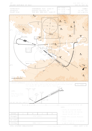
IAC chart of OITT
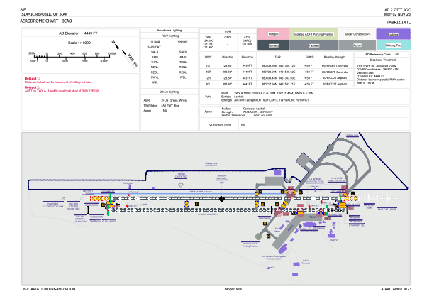
 ADC chart of OITT
 Satellite view of OITT
ADC chart of OITT
Satellite view of OITT
Sorry, we have no imagery here.
Sorry, we have no imagery here.
Sorry, we have no imagery here.
Sorry, we have no imagery here.
Sorry, we have no imagery here.
Sorry, we have no imagery here.


OITT - Tabriz Intl
Located in Tabriz, Iran, Islamic Republic of
ICAO - OITT, IATA - TBZ
Data provided by AirmateGeneral information
Coordinates: N38°8'2" E46°14'6"
Elevation is 4449 feet MSL.
View others Airports in East Azarbaijan Province
Operational data
Special qualification required
Current time UTC: 22:25:41
Current local time:
Weather
TAF: TAF OITT 291750Z 2918/3024 12008KT 8000 FEW035 SCT090 TEMPO 3010/3016 26014G26KT FEW030TCU SCT090
Communications frequencies: [VIEW]
Runways:
| RWY identifier | QFU | Length (ft) | Width (ft) | Surface | LDA (ft) |
| 12R | 129° | 12333 | 148 | ASP | |
| 30L | 309° | 12333 | 148 | ASP | |
| 12L | 129° | 11995 | 148 | ASP | |
| 30R | 309° | 11995 | 148 | ASP |
Airport contact information
Address: Tabriz Iran, Islamic Republic of
Satellite view of OITT
Sorry, we have no imagery here.
Sorry, we have no imagery here.
Sorry, we have no imagery here.
Sorry, we have no imagery here.
Sorry, we have no imagery here.
Sorry, we have no imagery here.