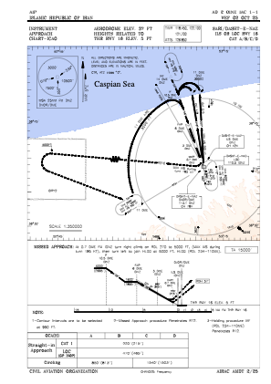
IAC chart of OINZ
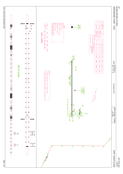
 ADC chart of OINZ
 Satellite view of OINZ

ADC chart of OINZ
Satellite view of OINZ
Sorry, we have no imagery here.
Sorry, we have no imagery here.
Sorry, we have no imagery here.
Sorry, we have no imagery here.
Sorry, we have no imagery here.
Sorry, we have no imagery here.


OINZ - Sari / Dasht-E-Naz
Located in Sari, Iran, Islamic Republic of
ICAO - OINZ, IATA - SRY
Data provided by AirmateGeneral information
Coordinates: N36°38'9" E53°11'37"
Elevation is 37 feet MSL.
View others Airports in Mazandaran Province
Operational data
Special qualification required
Current time UTC: 20:40:02
Current local time:
Weather
METAR: OINZ 272000Z 19004KT CAVOK 17/14 Q1013
TAF: TAF OINZ 271730Z 2718/2803 18006KT 9999 NSC PROB40 TEMPO 2723/2803 5000 BR FEW030 SCT070
Communications frequencies: [VIEW]
Runways:
| RWY identifier | QFU | Length (ft) | Width (ft) | Surface | LDA (ft) |
| 16 | 161° | 8671 | 148 | ASP | |
| 34 | 341° | 8671 | 148 | ASP |
Airport contact information
Address: Sari Iran, Islamic Republic of
Satellite view of OINZ
Sorry, we have no imagery here.
Sorry, we have no imagery here.
Sorry, we have no imagery here.
Sorry, we have no imagery here.
Sorry, we have no imagery here.
Sorry, we have no imagery here.