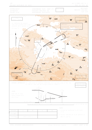
IAC chart of OIMN
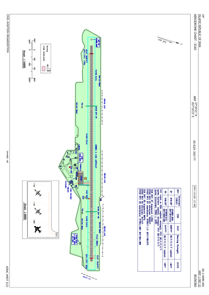
 ADC chart of OIMN
 Satellite view of OIMN

ADC chart of OIMN
Satellite view of OIMN
Sorry, we have no imagery here.
Sorry, we have no imagery here.
Sorry, we have no imagery here.
Sorry, we have no imagery here.
Sorry, we have no imagery here.
Sorry, we have no imagery here.


OIMN - Bojnord / Secondary International Aerodrome
Located in Bojnord, Iran, Islamic Republic of
ICAO - OIMN, IATA - BJB
Data provided by AirmateGeneral information
Coordinates: N37°29'21" E57°18'23"
Elevation is 3567 feet MSL.
View others Airports in North Khorasan Province
Operational data
Special qualification required
Current time UTC: 14:22:32
Current local time:
Weather
METAR: OIMN 301400Z 12006KT CAVOK 30/M13 Q1010
Communications frequencies: [VIEW]
Runways:
| RWY identifier | QFU | Length (ft) | Width (ft) | Surface | LDA (ft) |
| 07 | 70° | 14324 | 148 | ASP | |
| 25 | 250° | 14324 | 148 | ASP |
Airport contact information
Address: Bojnord Iran, Islamic Republic of
Satellite view of OIMN
Sorry, we have no imagery here.
Sorry, we have no imagery here.
Sorry, we have no imagery here.
Sorry, we have no imagery here.
Sorry, we have no imagery here.
Sorry, we have no imagery here.