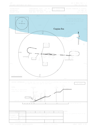
IAC chart of OIGG
 ADC chart of OIGG
 Satellite view of OIGG

ADC chart of OIGG
Satellite view of OIGG
Sorry, we have no imagery here.
Sorry, we have no imagery here.
Sorry, we have no imagery here.
Sorry, we have no imagery here.
Sorry, we have no imagery here.
Sorry, we have no imagery here.


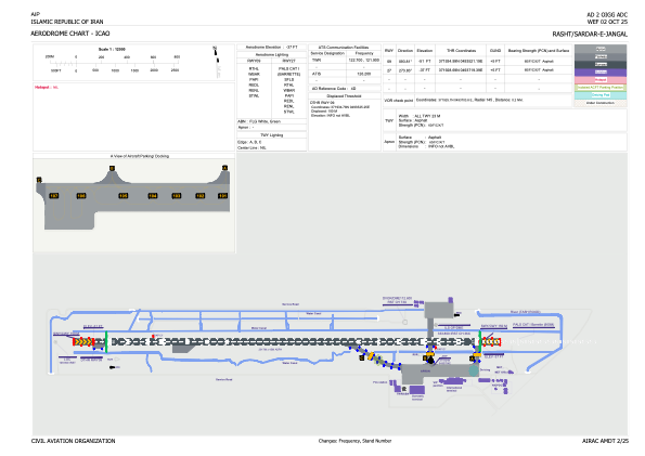
OIGG - Rasht / Sardar-E-Jangal / Secondary International Aerodrome
Located in Rasht, Iran, Islamic Republic of
ICAO - OIGG, IATA - RAS
Data provided by AirmateGeneral information
Coordinates: N37°19'24" E49°37'4"
Elevation is -37 feet MSL.
View others Airports in Gilan Province
Operational data
Special qualification required
Current time UTC: 10:39:44
Current local time:
Weather
METAR: OIGG 301030Z 05008KT CAVOK 29/16 Q1006
TAF: TAF OIGG 300830Z 3009/3018 26008KT 7000 FEW030 TEMPO 3011/3015 27012KT FEW030CB SCT080
Communications frequencies: [VIEW]
Runways:
| RWY identifier | QFU | Length (ft) | Width (ft) | Surface | LDA (ft) |
| 09 | 94° | 9570 | 148 | ASP | |
| 27 | 274° | 9570 | 148 | ASP |
Airport contact information
Address: Rasht Iran, Islamic Republic of
Satellite view of OIGG
Sorry, we have no imagery here.
Sorry, we have no imagery here.
Sorry, we have no imagery here.
Sorry, we have no imagery here.
Sorry, we have no imagery here.
Sorry, we have no imagery here.