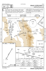
IAC chart of O43
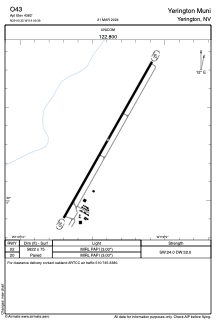
 ADC chart of O43
 Satellite view of O43

ADC chart of O43
Satellite view of O43
Sorry, we have no imagery here.
Sorry, we have no imagery here.
Sorry, we have no imagery here.
Sorry, we have no imagery here.
Sorry, we have no imagery here.


O43 - Yerington Muni
Located in Yerington, United States
ICAO - O43, IATA -
Data provided by AirmateGeneral information
Coordinates: N39°0'19" W119°9'24"
Elevation is 4382 feet MSL.
Magnetic variation is 13° East View others Airports in Nevada
Operational data
Special qualification required
Current time UTC: 15:20:56
Current local time:
Weather at : KMEV - Minden-Tahoe ( 51 km )
METAR: KMEV 301455Z AUTO 00000KT 10SM CLR 18/03 A3029 RMK AO2
TAF: KMEV 301120Z 3012/3112 VRB05KT P6SM SKC FM302100 32007KT P6SM SKC FM310000 31010G18KT P6SM SKC FM310400 VRB05KT P6SM FEW250
Communications frequencies: [VIEW]
Runways:
| RWY identifier | QFU | Length (ft) | Width (ft) | Surface | LDA (ft) |
| 02 | 0° | 5822 | 75 | ASPH | |
| 20 | 0° | 5822 | 75 | ASPH |
Airport contact information
Address: Yerington United States
Satellite view of O43
Sorry, we have no imagery here.
Sorry, we have no imagery here.
Sorry, we have no imagery here.
Sorry, we have no imagery here.
Sorry, we have no imagery here.