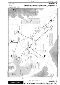
VAC chart of NZWF
 IAC chart of NZWF
 Satellite view of NZWF
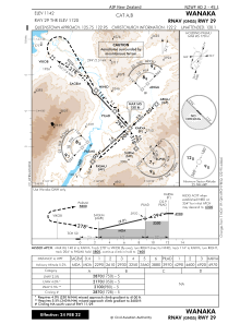
IAC chart of NZWF
Satellite view of NZWF
Sorry, we have no imagery here.
Sorry, we have no imagery here.
Sorry, we have no imagery here.
Sorry, we have no imagery here.
Sorry, we have no imagery here.
Sorry, we have no imagery here.


NZWF - Wanaka
Located in Wanaka, New Zealand
ICAO - NZWF, IATA - WKA
Data provided by AirmateGeneral information
Coordinates: S44°43'20" E169°14'44"
Elevation is 1142 feet MSL.
Magnetic variation is +24° East View others Airports in Otago Region
Operational data
Special qualification required
Current time UTC: 10:59:05
Current local time:
Weather at : NZQN - Queenstown ( 52 km )
METAR: NZQN 281030Z AUTO 18005KT 9999 -RA OVC070/// 08/05 Q0993
TAF: TAF AMD NZQN 272354Z 2723/2812 16008KT 9999 BKN070
Communications frequencies: [VIEW]
Runways:
| RWY identifier | QFU | Length (ft) | Width (ft) | Surface | LDA (ft) |
| 11 | 139° | 2953 | 197 | GRASS | 3937 |
| 29 | 319° | 3937 | 98 | BITUM | 3937 |
| 29 GR | 0° | 2953 | 197 | GRASS | |
| 11G | 0° | 0 | 0 | UNK | 2953 |
| 29G | 0° | 0 | 0 | UNK | 2953 |
Airport contact information
Address: Wanaka New Zealand
