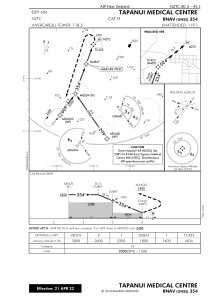
IAC chart of NZTC
 Satellite view of NZTC
Satellite view of NZTC
Sorry, we have no imagery here.
Sorry, we have no imagery here.
Sorry, we have no imagery here.
Sorry, we have no imagery here.
Sorry, we have no imagery here.
Sorry, we have no imagery here.


NZTC - Tapanui Medical Centre
Located in Gore Township, New Zealand
ICAO - , IATA -
Data provided by AirmateGeneral information
Coordinates: S45°56'17" E169°15'48"
Elevation is 606 feet MSL.
Magnetic variation is +26° East View others Airports in Otago Region
Operational data
Special qualification required
Current time UTC: 07:00:36
Current local time:
Communications frequencies: [VIEW]
Runways:
Airport contact information
Address: Gore Township New Zealand
Satellite view of NZTC
Sorry, we have no imagery here.
Sorry, we have no imagery here.
Sorry, we have no imagery here.
Sorry, we have no imagery here.
Sorry, we have no imagery here.
Sorry, we have no imagery here.