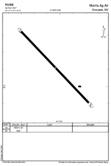
ADC chart of NV88
 Satellite view of NV88

Satellite view of NV88
Sorry, we have no imagery here.
Sorry, we have no imagery here.
Sorry, we have no imagery here.
Sorry, we have no imagery here.
Sorry, we have no imagery here.
Sorry, we have no imagery here.


NV88 - Morris Ag Air
Located in Orovada, United States
ICAO - NV88, IATA -
Data provided by AirmateGeneral information
Coordinates: N41°33'7" W117°50'2"
Elevation is 4227 feet MSL.
View others Airports in Nevada
Operational data
Special qualification required
Current time UTC: 13:14:11
Current local time:
Weather at : KWMC - Winnemucca Muni ( 73 km )
METAR: KWMC 301256Z AUTO 31006KT 10SM CLR 12/03 A3024 RMK AO2 SLP195 T01220033 TSNO
TAF: KWMC 301134Z 3012/3112 35010KT P6SM SKC FM301400 03012G22KT P6SM SKC FM301800 35008KT P6SM SKC FM310600 10006KT P6SM SKC
Communications frequencies: [VIEW]
Runways:
| RWY identifier | QFU | Length (ft) | Width (ft) | Surface | LDA (ft) |
| 14 | 0° | 3350 | 25 | OTHER | |
| 32 | 0° | 3350 | 25 | OTHER |
Airport contact information
Address: Orovada United States
Satellite view of NV88
Sorry, we have no imagery here.
Sorry, we have no imagery here.
Sorry, we have no imagery here.
Sorry, we have no imagery here.
Sorry, we have no imagery here.
Sorry, we have no imagery here.