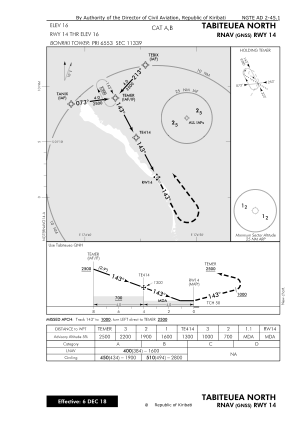
IAC chart of NGTE
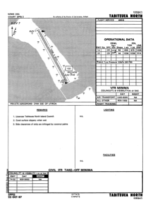
 ADC chart of NGTE
 Satellite view of NGTE

ADC chart of NGTE
Satellite view of NGTE
Sorry, we have no imagery here.
Sorry, we have no imagery here.
Sorry, we have no imagery here.
Sorry, we have no imagery here.
Sorry, we have no imagery here.
Sorry, we have no imagery here.


NGTE - Tabiteuea North
Located in , Kiribati
ICAO - NGTE, IATA - TBF
Data provided by AirmateGeneral information
Coordinates: S1°13'25" E174°46'33"
Elevation is 16 feet MSL.
Magnetic variation is 10° East View others Airports in Gilbert Islands
Operational data
Special qualification required
Current time UTC: 06:17:51
Current local time:
Weather at : - ( 0 km )
METAR: KEGI 290611Z AUTO 03009KT 10SM -VCTSRA FEW002 SCT039 OVC055 22/20 A3008 RMK AO2 LTG DSNT N-E AND SW RAE11 TSE11 SLP185 $
Communications frequencies: [VIEW]
Runways:
| RWY identifier | QFU | Length (ft) | Width (ft) | Surface | LDA (ft) |
| 14 | 153° | 3399 | 98 | COR | |
| 32 | 333° | 3399 | 98 | COR |
Airport contact information
Address: Kiribati
Satellite view of NGTE
Sorry, we have no imagery here.
Sorry, we have no imagery here.
Sorry, we have no imagery here.
Sorry, we have no imagery here.
Sorry, we have no imagery here.
Sorry, we have no imagery here.