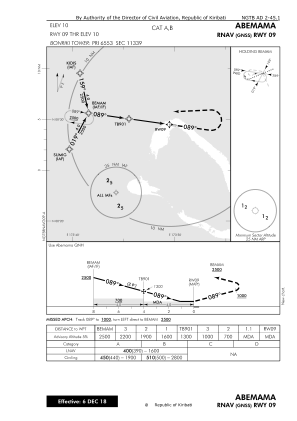
IAC chart of NGTB
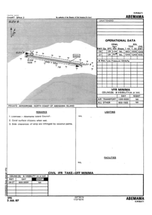
 ADC chart of NGTB
 Satellite view of NGTB

ADC chart of NGTB
Satellite view of NGTB
Sorry, we have no imagery here.
Sorry, we have no imagery here.
Sorry, we have no imagery here.
Sorry, we have no imagery here.
Sorry, we have no imagery here.
Sorry, we have no imagery here.


NGTB - Abemama
Located in , Kiribati
ICAO - NGTB, IATA - AEA
Data provided by AirmateGeneral information
Coordinates: N0°29'26" E173°49'53"
Elevation is 8 feet MSL.
Magnetic variation is 9° East View others Airports in Gilbert Islands
Operational data
Special qualification required
Current time UTC: 22:10:17
Current local time:
Weather at : - ( 0 km )
METAR: YHID 312206Z AUTO 15009KT 9999 // OVC013 27/25 Q1012
Communications frequencies: [VIEW]
Runways:
| RWY identifier | QFU | Length (ft) | Width (ft) | Surface | LDA (ft) |
| 09 | 0° | 4098 | 98 | UNK | |
| 27 | 0° | 4098 | 98 | UNK |
Airport contact information
Address: Kiribati
Satellite view of NGTB
Sorry, we have no imagery here.
Sorry, we have no imagery here.
Sorry, we have no imagery here.
Sorry, we have no imagery here.
Sorry, we have no imagery here.
Sorry, we have no imagery here.