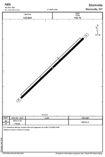
ADC chart of N69
 Satellite view of N69

Satellite view of N69
Sorry, we have no imagery here.
Sorry, we have no imagery here.
Sorry, we have no imagery here.
Sorry, we have no imagery here.
Sorry, we have no imagery here.
Sorry, we have no imagery here.


N69 - Stormville
Located in Stormville, United States
ICAO - N69, IATA -
Data provided by AirmateGeneral information
Coordinates: N41°34'37" W73°43'56"
Elevation is 358 feet MSL.
Magnetic variation is -12° East View others Airports in New York
Operational data
Special qualification required
Current time UTC: 23:28:43
Current local time:
Weather at : KPOU - Hudson Valley Rgnl ( 14 km )
METAR: KPOU 272253Z 20003KT 10SM CLR 22/07 A3027 RMK AO2 SLP245 T02220072
TAF: KPOU 272320Z 2800/2824 VRB03KT P6SM BKN200 FM281500 19006KT P6SM SCT050 BKN150 PROB30 2822/2824 6SM -RA SCT025 OVC050
Communications frequencies: [VIEW]
Runways:
| RWY identifier | QFU | Length (ft) | Width (ft) | Surface | LDA (ft) |
| 06 | 46° | 3315 | 50 | ASPH | |
| 24 | 226° | 3315 | 50 | ASPH |
Airport contact information
Address: Stormville United States
Satellite view of N69
Sorry, we have no imagery here.
Sorry, we have no imagery here.
Sorry, we have no imagery here.
Sorry, we have no imagery here.
Sorry, we have no imagery here.
Sorry, we have no imagery here.