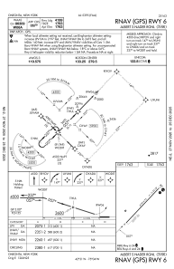
IAC chart of N66
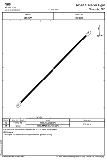
 ADC chart of N66
 Satellite view of N66

ADC chart of N66
Satellite view of N66
Sorry, we have no imagery here.
Sorry, we have no imagery here.
Sorry, we have no imagery here.
Sorry, we have no imagery here.
Sorry, we have no imagery here.
Sorry, we have no imagery here.


N66 - Albert S Nader Rgnl
Located in Oneonta, United States
ICAO - N66, IATA -
Data provided by AirmateGeneral information
Coordinates: N42°31'29" W75°3'52"
Elevation is 1763 feet MSL.
Magnetic variation is -13° East View others Airports in New York
Operational data
Special qualification required
Current time UTC: 18:54:03
Current local time:
Weather at : KOIC - Lt Warren Eaton ( 38 km )
METAR: KOIC 281835Z AUTO 19009G15KT 10SM SCT055 SCT120 21/08 A3020 RMK AO2
Communications frequencies: [VIEW]
Runways:
| RWY identifier | QFU | Length (ft) | Width (ft) | Surface | LDA (ft) |
| 06 | 44° | 4199 | 75 | ASPH | |
| 24 | 224° | 4199 | 75 | ASPH |
Airport contact information
Address: Oneonta United States
Satellite view of N66
Sorry, we have no imagery here.
Sorry, we have no imagery here.
Sorry, we have no imagery here.
Sorry, we have no imagery here.
Sorry, we have no imagery here.
Sorry, we have no imagery here.