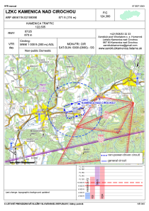
VAC chart of LZKC
 Satellite view of LZKC

Satellite view of LZKC
Sorry, we have no imagery here.
Sorry, we have no imagery here.
Sorry, we have no imagery here.
Sorry, we have no imagery here.
Sorry, we have no imagery here.


LZKC - Kamenica Nad Cirochou
Located in Humenne, Slovakia
ICAO - LZKC, IATA -
Data provided by AirmateGeneral information
Coordinates: N48°56'11" E21°59'39"
Elevation is 570 feet MSL.
Magnetic variation is 5.2415° East View others Airports in Prešov
Operational data
Special qualification required
Current time UTC: 14:57:30
Current local time:
Communications frequencies: [VIEW]
Runways:
| RWY identifier | QFU | Length (ft) | Width (ft) | Surface | LDA (ft) |
| 07 | 0° | 2854 | 98 | UNK | |
| 25 | 0° | 2854 | 98 | UNK |
Airport contact information
Address: Humenne Slovakia
Satellite view of LZKC
Sorry, we have no imagery here.
Sorry, we have no imagery here.
Sorry, we have no imagery here.
Sorry, we have no imagery here.
Sorry, we have no imagery here.