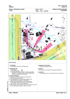
VAC chart of LTHF
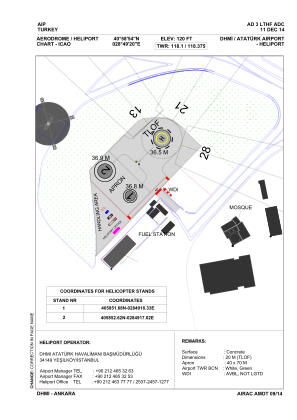
 ADC chart of LTHF
 Satellite view of LTHF
ADC chart of LTHF
Satellite view of LTHF
Sorry, we have no imagery here.
Sorry, we have no imagery here.
Sorry, we have no imagery here.
Sorry, we have no imagery here.
Sorry, we have no imagery here.
Sorry, we have no imagery here.


LTHF - Dhmi Ataturk Heliport
Located in Istanbul, Turkey
ICAO - , IATA -
Data provided by AirmateGeneral information
Coordinates: N40°58'54" E28°49'20"
Elevation is 120 feet MSL.
Magnetic variation is 4° East View others Airports in Istanbul
Operational data
Special qualification required
Current time UTC: 22:36:29
Current local time:
Weather at : LTBX - Istanbul Samandira ( 33 km )
TAF: TAF LTBX 221340Z 2215/2224 VRB02KT CAVOK BECMG 2221/2224 21012KT
Communications frequencies: [VIEW]
Runways:
Airport contact information
Address: Istanbul Turkey
Satellite view of LTHF
Sorry, we have no imagery here.
Sorry, we have no imagery here.
Sorry, we have no imagery here.
Sorry, we have no imagery here.
Sorry, we have no imagery here.
Sorry, we have no imagery here.