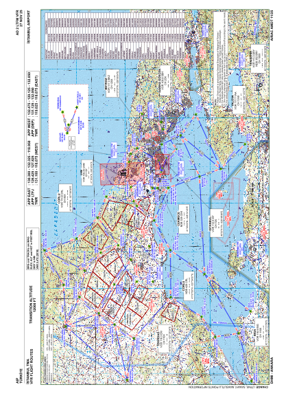
VAC chart of LTFM
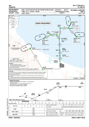
 IAC chart of LTFM
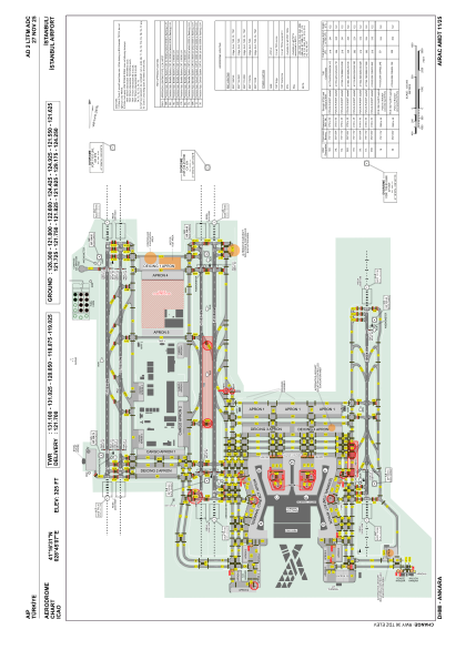
 ADC chart of LTFM
 Satellite view of LTFM
IAC chart of LTFMADC chart of LTFM
Satellite view of LTFM
Sorry, we have no imagery here.
Sorry, we have no imagery here.
Sorry, we have no imagery here.
Sorry, we have no imagery here.
Sorry, we have no imagery here.
Sorry, we have no imagery here.


LTFM - Istanbul
Located in Istanbul, Turkey
ICAO - , IATA - IST
Data provided by AirmateGeneral information
Coordinates: N41°16'31" E28°45'7"
Elevation is 325 feet MSL.
Magnetic variation is 5.4° East View others Airports in Istanbul
Operational data
Special qualification required
Current time UTC: 14:51:26
Current local time:
Weather
METAR: LTFM 241420Z 03010KT CAVOK 20/14 Q1011 NOSIG RMK RWY17L 04007KT RWY34L 03009KT RWY16R 04007KT 010V070 RWY36 05009KT RWY18 05007KT
TAF: TAF LTFM 241040Z 2412/2518 35009KT CAVOK BECMG 2412/2415 05010KT BECMG 2417/2419 34008KT BECMG 2419/2422 SCT020 BKN120 TEMPO 2422/2501 2500 BR BECMG 2500/2503 BKN005 BKN020 PROB30 TEMPO 2501/2505 1200 BCFG BKN002 PROB40 TEMPO 2505/2508 -SHRA BECMG 2508/2511 SCT020 BKN100
Communications frequencies: [VIEW]
Runways:
| RWY identifier | QFU | Length (ft) | Width (ft) | Surface | LDA (ft) |
| 16R | 179° | 12303 | 197 | ASPH | 12303 |
| 34L | 359° | 12303 | 197 | ASPH | 12303 |
| 16L | 179° | 12303 | 148 | ASPH | 12303 |
| 34R | 359° | 12303 | 148 | ASPH | 12303 |
| 17L | 179° | 13451 | 197 | ASPH | 13451 |
| 35R | 359° | 13451 | 197 | ASPH | 13451 |
| 17R | 179° | 13451 | 148 | ASPH | 13451 |
| 35L | 359° | 13451 | 148 | ASPH | 13451 |
| 18 | 179° | 10039 | 148 | CONC+ASPH | 10039 |
| 36 | 359° | 10039 | 148 | CONC+ASPH | 10039 |
Airport contact information
Address: Istanbul Turkey