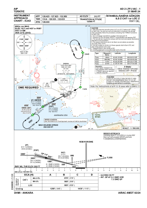
IAC chart of LTFJ
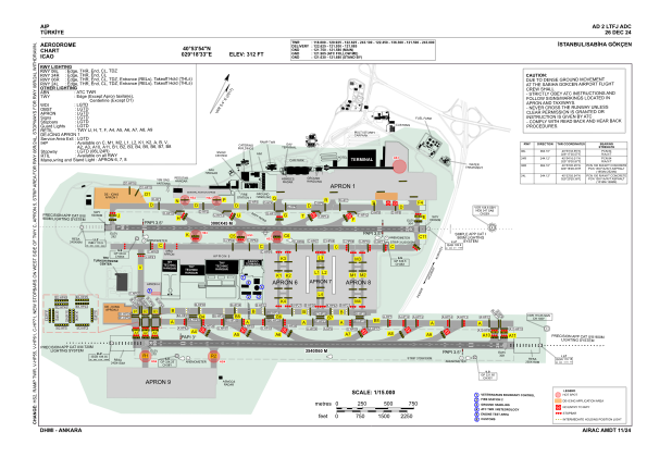
 ADC chart of LTFJ
 Satellite view of LTFJ

ADC chart of LTFJ
Satellite view of LTFJ
Sorry, we have no imagery here.
Sorry, we have no imagery here.
Sorry, we have no imagery here.
Sorry, we have no imagery here.
Sorry, we have no imagery here.
Sorry, we have no imagery here.


LTFJ - Istanbul Sabiha Gokcen
Located in Istanbul, Turkey
ICAO - LTFJ, IATA - SAW
Data provided by AirmateGeneral information
Coordinates: N40°53'54" E29°18'33"
Elevation is 312 feet MSL.
Magnetic variation is 5.4° East View others Airports in Istanbul
Operational data
Special qualification required
Current time UTC: 03:07:51
Current local time:
Weather
METAR: LTFJ 290250Z 06003KT CAVOK 15/12 Q1010 NOSIG RMK RWY24R 02004KT RWY06R 02004KT RWY24L 05003KT 020V090
TAF: TAF LTFJ 282240Z 2900/2924 04007KT CAVOK BECMG 2906/2909 SCT035 PROB30 TEMPO 2909/2913 34015G25KT -TSRA FEW020CB BKN030 BECMG 2913/2915 CAVOK
Communications frequencies: [VIEW]
Runways:
| RWY identifier | QFU | Length (ft) | Width (ft) | Surface | LDA (ft) |
| 06L | 64° | 9843 | 148 | CONC | 9547 |
| 24R | 244° | 9843 | 148 | CONC | 9843 |
| 06R | 64° | 11614 | 197 | CONC+ASPH | 11614 |
| 24L | 244° | 11614 | 197 | CONC+ASPH | 11614 |
Airport contact information
Address: Istanbul Turkey
Satellite view of LTFJ
Sorry, we have no imagery here.
Sorry, we have no imagery here.
Sorry, we have no imagery here.
Sorry, we have no imagery here.
Sorry, we have no imagery here.
Sorry, we have no imagery here.