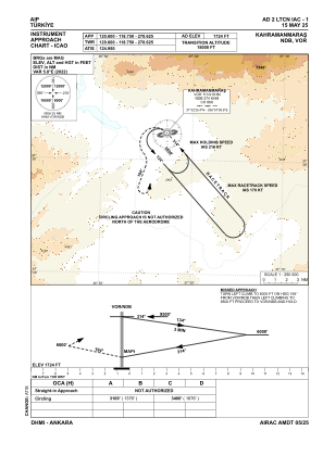
IAC chart of LTCN
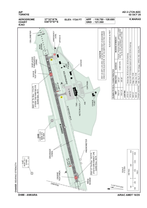
 ADC chart of LTCN
 Satellite view of LTCN

ADC chart of LTCN
Satellite view of LTCN
Sorry, we have no imagery here.
Sorry, we have no imagery here.
Sorry, we have no imagery here.
Sorry, we have no imagery here.
Sorry, we have no imagery here.
Sorry, we have no imagery here.


LTCN - Kahramanmaras
Located in Kahramanmaras, Turkey
ICAO - LTCN, IATA - KCM
Data provided by AirmateGeneral information
Coordinates: N37°32'18" E36°57'7"
Elevation is 1724 feet MSL.
Magnetic variation is 5.4° East View others Airports in Kahramanmaras
Operational data
Special qualification required
Current time UTC: 13:25:23
Current local time:
Weather
METAR: LTCN 251250Z 32011KT 290V360 9999 FEW040 36/04 Q1008
TAF: TAF LTCN 251040Z 2512/2521 29015KT 9999 FEW040
Communications frequencies: [VIEW]
Runways:
| RWY identifier | QFU | Length (ft) | Width (ft) | Surface | LDA (ft) |
| 07 | 75° | 7546 | 148 | ASPH | 7546 |
| 25 | 0° | 7546 | 148 | ASPH | 6562 |
Airport contact information
Address: Kahramanmaras Turkey
Satellite view of LTCN
Sorry, we have no imagery here.
Sorry, we have no imagery here.
Sorry, we have no imagery here.
Sorry, we have no imagery here.
Sorry, we have no imagery here.
Sorry, we have no imagery here.