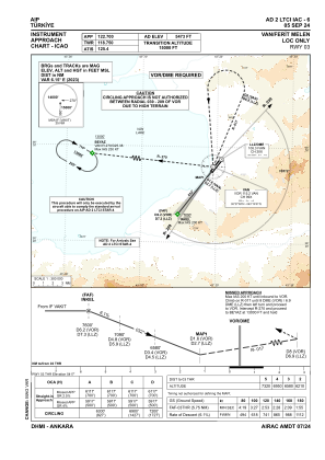
IAC chart of LTCI
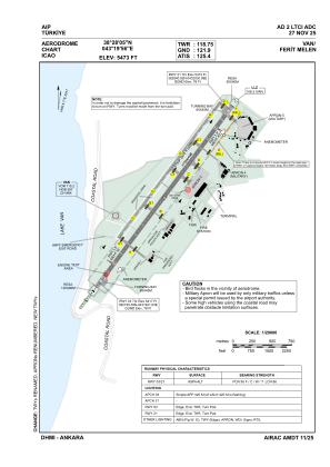
 ADC chart of LTCI
 Satellite view of LTCI

ADC chart of LTCI
Satellite view of LTCI
Sorry, we have no imagery here.
Sorry, we have no imagery here.
Sorry, we have no imagery here.
Sorry, we have no imagery here.
Sorry, we have no imagery here.
Sorry, we have no imagery here.


LTCI - Van Ferit Melen
Located in Van, Turkey
ICAO - LTCI, IATA - VAN
Data provided by AirmateGeneral information
Coordinates: N38°28'5" E43°19'56"
Elevation is 5473 feet MSL.
Magnetic variation is 5.7° East View others Airports in Van
Operational data
Special qualification required
Current time UTC: 01:19:19
Current local time:
Weather
METAR: LTCI 220050Z VRB02KT CAVOK 09/04 Q1020 NOSIG
TAF: TAF LTCI 212240Z 2200/2209 10007KT CAVOK BECMG 2205/2206 30010KT BECMG 2208/2209 FEW040
Communications frequencies: [VIEW]
Runways:
| RWY identifier | QFU | Length (ft) | Width (ft) | Surface | LDA (ft) |
| 03 | 38° | 9022 | 148 | ASPH | 9022 |
| 21 | 218° | 9022 | 148 | ASPH | 9022 |
Airport contact information
Address: Van Turkey
Satellite view of LTCI
Sorry, we have no imagery here.
Sorry, we have no imagery here.
Sorry, we have no imagery here.
Sorry, we have no imagery here.
Sorry, we have no imagery here.
Sorry, we have no imagery here.