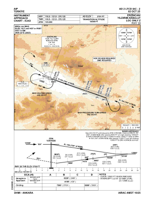
IAC chart of LTCD
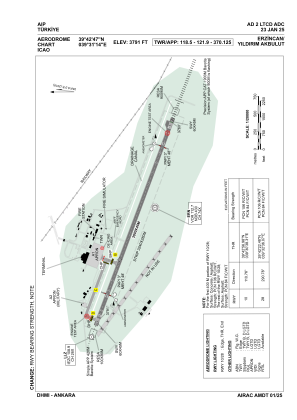
 ADC chart of LTCD
 Satellite view of LTCD

ADC chart of LTCD
Satellite view of LTCD
Sorry, we have no imagery here.
Sorry, we have no imagery here.
Sorry, we have no imagery here.
Sorry, we have no imagery here.
Sorry, we have no imagery here.
Sorry, we have no imagery here.


LTCD - Erzincan Yildirim Akbulut
Located in Erzincan, Turkey
ICAO - LTCD, IATA - ERC
Data provided by AirmateGeneral information
Coordinates: N39°42'47" E39°31'14"
Elevation is 3791 feet MSL.
Magnetic variation is 6.0° East View others Airports in Erzincan
Operational data
Special qualification required
Current time UTC: 22:28:41
Current local time:
Weather
METAR: LTCD 232150Z 30004KT 270V340 CAVOK 15/03 Q1015 NOSIG
TAF: TAF LTCD 231940Z 2321/2406 27009KT CAVOK
Communications frequencies: [VIEW]
Runways:
| RWY identifier | QFU | Length (ft) | Width (ft) | Surface | LDA (ft) |
| 10 | 111° | 9843 | 148 | CONC+ASPH | 9843 |
| 28 | 291° | 9843 | 148 | CONC+ASPH | 9843 |
Airport contact information
Address: Erzincan Turkey
Satellite view of LTCD
Sorry, we have no imagery here.
Sorry, we have no imagery here.
Sorry, we have no imagery here.
Sorry, we have no imagery here.
Sorry, we have no imagery here.
Sorry, we have no imagery here.