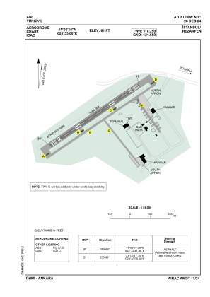
ADC chart of LTBW
 Satellite view of LTBW

Satellite view of LTBW
Sorry, we have no imagery here.
Sorry, we have no imagery here.
Sorry, we have no imagery here.
Sorry, we have no imagery here.
Sorry, we have no imagery here.
Sorry, we have no imagery here.


LTBW - Istanbul Hezarfen
Located in Istanbul, Turkey
ICAO - LTBW, IATA -
Data provided by AirmateGeneral information
Coordinates: N41°6'15" E28°33'0"
Elevation is 61 feet MSL.
Magnetic variation is 6.0° East View others Airports in Istanbul
Operational data
Special qualification required
Current time UTC: 22:49:00
Current local time:
Weather at : LTFM - Istanbul ( 25 km )
METAR: LTFM 252220Z 18009KT 9999 SCT032 BKN080 18/16 Q1008 NOSIG RMK RWY17L 18008KT 140V200 RWY34L 18007KT RWY16R 18008KT RWY36 17007KT RWY18 17009KT
TAF: TAF LTFM 251640Z 2518/2624 02007KT 9999 -SHRA BKN008 BKN022 BECMG 2518/2521 14014KT PROB40 TEMPO 2522/2602 20025G40KT -TSRA SCT008 FEW018CB BKN025 BECMG 2602/2604 23012KT PROB30 TEMPO 2602/2606 -TSRA SCT008 FEW018CB BKN025 BECMG 2610/2613 03010KT SCT035 BECMG 2617/2620 24010KT
Communications frequencies: [VIEW]
Runways:
| RWY identifier | QFU | Length (ft) | Width (ft) | Surface | LDA (ft) |
| 05 | 56° | 1755 | 59 | ASPH | 1755 |
| 23 | 236° | 1755 | 59 | ASPH | 1755 |
Airport contact information
Address: Istanbul Turkey
Satellite view of LTBW
Sorry, we have no imagery here.
Sorry, we have no imagery here.
Sorry, we have no imagery here.
Sorry, we have no imagery here.
Sorry, we have no imagery here.
Sorry, we have no imagery here.