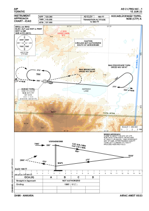
IAC chart of LTBQ
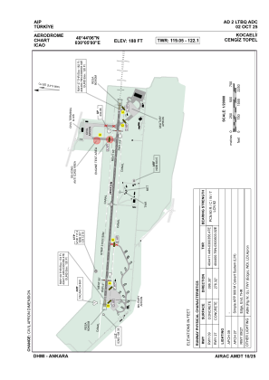
 ADC chart of LTBQ
 Satellite view of LTBQ

ADC chart of LTBQ
Satellite view of LTBQ
Sorry, we have no imagery here.
Sorry, we have no imagery here.
Sorry, we have no imagery here.
Sorry, we have no imagery here.
Sorry, we have no imagery here.
Sorry, we have no imagery here.


LTBQ - Kocaeli Cengiz Topel
Located in Kocaeli/Topel, Turkey
ICAO - LTBQ, IATA - KCO
Data provided by AirmateGeneral information
Coordinates: N40°44'6" E30°4'60"
Elevation is 188 feet MSL.
Magnetic variation is 5.4° East View others Airports in Kocaeli
Operational data
Special qualification required
Current time UTC: 15:03:02
Current local time:
Weather
METAR: LTBQ 281450Z 27010KT 230V290 9999 FEW040 SCT200 24/10 Q1011 NOSIG
TAF: TAF LTBQ 281340Z 2815/2824 VRB02KT 9999 FEW040
Communications frequencies: [VIEW]
Runways:
| RWY identifier | QFU | Length (ft) | Width (ft) | Surface | LDA (ft) |
| 09 | 96° | 9810 | 98 | CONC | 9810 |
| 27 | 276° | 9810 | 98 | CONC | 9810 |
Airport contact information
Address: Kocaeli/Topel Turkey
Satellite view of LTBQ
Sorry, we have no imagery here.
Sorry, we have no imagery here.
Sorry, we have no imagery here.
Sorry, we have no imagery here.
Sorry, we have no imagery here.
Sorry, we have no imagery here.