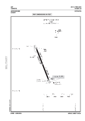
ADC chart of LTBN
 Satellite view of LTBN

Satellite view of LTBN
Sorry, we have no imagery here.
Sorry, we have no imagery here.
Sorry, we have no imagery here.
Sorry, we have no imagery here.
Sorry, we have no imagery here.
Sorry, we have no imagery here.


LTBN - Kutahya
Located in Kutahya, Turkey
ICAO - LTBN, IATA -
Data provided by AirmateGeneral information
Coordinates: N39°25'36" E30°1'1"
Elevation is 3026 feet MSL.
Magnetic variation is 4.8° East View others Airports in Kütahya
Operational data
Special qualification required
Current time UTC: 19:35:19
Current local time:
Weather
TAF: TAF LTBN 281340Z 2815/2824 33012KT 9999 SCT040 BECMG 2816/2818 VRB02KT
Communications frequencies: [VIEW]
Runways:
| RWY identifier | QFU | Length (ft) | Width (ft) | Surface | LDA (ft) |
| 15 | 159° | 4954 | 138 | ASPH | |
| 33 | 339° | 4954 | 138 | ASPH |
Airport contact information
Address: Kutahya Turkey
Satellite view of LTBN
Sorry, we have no imagery here.
Sorry, we have no imagery here.
Sorry, we have no imagery here.
Sorry, we have no imagery here.
Sorry, we have no imagery here.
Sorry, we have no imagery here.