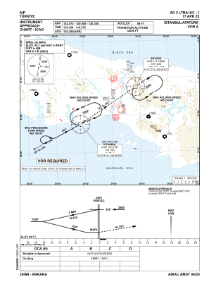
IAC chart of LTBA
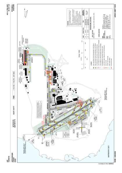
 ADC chart of LTBA
 Satellite view of LTBA

ADC chart of LTBA
Satellite view of LTBA
Sorry, we have no imagery here.
Sorry, we have no imagery here.
Sorry, we have no imagery here.
Sorry, we have no imagery here.
Sorry, we have no imagery here.
Sorry, we have no imagery here.


LTBA - Istanbul Ataturk
Located in Istanbul, Turkey
ICAO - LTBA, IATA - ISL
Data provided by AirmateGeneral information
Coordinates: N40°58'34" E28°48'51"
Elevation is 94 feet MSL.
Magnetic variation is 5.4° East View others Airports in Istanbul
Operational data
Special qualification required
Current time UTC: 15:09:11
Current local time:
Weather at : LTFM - Istanbul ( 34 km )
METAR: LTFM 251450Z 01011KT 9999 BKN008 BKN022 16/14 Q1010 NOSIG RMK RWY17L 02008KT RWY34L 36010KT RWY16R 01008KT RWY36 01011KT RWY18 01008KT
TAF: TAF LTFM 251040Z 2512/2618 35014KT 9999 BKN009 BKN020 TEMPO 2512/2516 -SHRA BECMG 2513/2516 VRB02KT SCT035 BKN100 BECMG 2518/2521 14012KT -SHRA BKN028 BKN090 PROB30 TEMPO 2523/2603 18025G35KT -TSRA SCT008 FEW018CB BKN025 BECMG 2602/2604 23012KT PROB40 TEMPO 2603/2607 -TSRA SCT008 FEW018CB BKN025 BECMG 2609/2612 SCT035
Communications frequencies: [VIEW]
Runways:
| RWY identifier | QFU | Length (ft) | Width (ft) | Surface | LDA (ft) |
| 05 | 59° | 8465 | 197 | ASPH | 8038 |
| 23 | 239° | 8465 | 197 | ASPH | 8465 |
Airport contact information
Address: Istanbul Turkey
Satellite view of LTBA
Sorry, we have no imagery here.
Sorry, we have no imagery here.
Sorry, we have no imagery here.
Sorry, we have no imagery here.
Sorry, we have no imagery here.
Sorry, we have no imagery here.