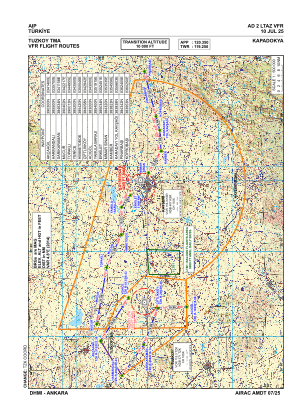
VAC chart of LTAZ
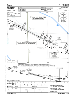
 IAC chart of LTAZ
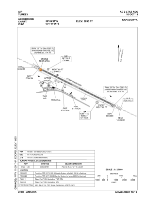
 ADC chart of LTAZ
 Satellite view of LTAZ

IAC chart of LTAZADC chart of LTAZ
Satellite view of LTAZ
Sorry, we have no imagery here.
Sorry, we have no imagery here.
Sorry, we have no imagery here.
Sorry, we have no imagery here.
Sorry, we have no imagery here.
Sorry, we have no imagery here.


LTAZ - Kapadokya
Located in Nevsehir, Turkey
ICAO - LTAZ, IATA - NAV
Data provided by AirmateGeneral information
Coordinates: N38°46'31" E34°31'36"
Elevation is 3090 feet MSL.
Magnetic variation is 5.5° East View others Airports in Nevsehir
Operational data
Special qualification required
Current time UTC: 10:02:17
Current local time:
Weather
METAR: LTAZ 220950Z VRB07KT CAVOK 25/M02 Q1018 RMK RWY29 VRB04KT
TAF: TAF LTAZ 220440Z 2206/2306 VRB02KT CAVOK PROB40 TEMPO 2216/2220 34015KT
Communications frequencies: [VIEW]
Runways:
| RWY identifier | QFU | Length (ft) | Width (ft) | Surface | LDA (ft) |
| 11 | 117° | 9843 | 148 | CONC | 9843 |
| 29 | 297° | 9843 | 148 | CONC | 9843 |
Airport contact information
Address: Nevsehir Turkey
Satellite view of LTAZ
Sorry, we have no imagery here.
Sorry, we have no imagery here.
Sorry, we have no imagery here.
Sorry, we have no imagery here.
Sorry, we have no imagery here.
Sorry, we have no imagery here.