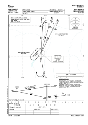
IAC chart of LTAL
 ADC chart of LTAL
 Satellite view of LTAL

ADC chart of LTAL
Satellite view of LTAL
Sorry, we have no imagery here.
Sorry, we have no imagery here.
Sorry, we have no imagery here.
Sorry, we have no imagery here.
Sorry, we have no imagery here.
Sorry, we have no imagery here.


LTAL - Kastamonu
Located in Kastamonu, Turkey
ICAO - LTAL, IATA - KFS
Data provided by AirmateGeneral information
Coordinates: N41°19'1" E33°47'46"
Elevation is 3524 feet MSL.
Magnetic variation is 5.9° East View others Airports in Kastamonu
Operational data
Special qualification required
Current time UTC: 05:34:06
Current local time:
Weather
METAR: LTAL 240450Z VRB01KT CAVOK 17/11 Q1016
TAF: TAF LTAL 240440Z 2406/2415 VRB02KT CAVOK BECMG 2408/2411 SCT033 PROB30 2411/2415 30015G25KT -TSRA FEW020CB BKN028
Communications frequencies: [VIEW]
Runways:
| RWY identifier | QFU | Length (ft) | Width (ft) | Surface | LDA (ft) |
| 18 | 187° | 7382 | 148 | ASPH | 7382 |
| 36 | 7° | 7382 | 148 | ASPH | 7382 |
Airport contact information
Address: Kastamonu Turkey
Satellite view of LTAL
Sorry, we have no imagery here.
Sorry, we have no imagery here.
Sorry, we have no imagery here.
Sorry, we have no imagery here.
Sorry, we have no imagery here.
Sorry, we have no imagery here.