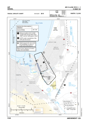
VAC chart of LLHA
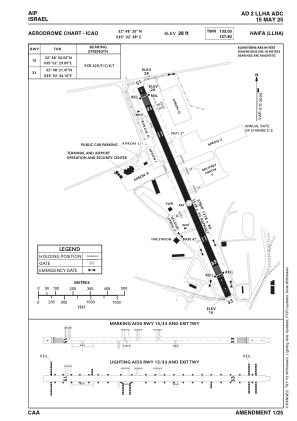
 ADC chart of LLHA
 Satellite view of LLHA

ADC chart of LLHA
Satellite view of LLHA
Sorry, we have no imagery here.
Sorry, we have no imagery here.
Sorry, we have no imagery here.
Sorry, we have no imagery here.
Sorry, we have no imagery here.
Sorry, we have no imagery here.


LLHA - Haifa
Located in Haifa, Israel
ICAO - LLHA, IATA - HFA
Data provided by AirmateGeneral information
Coordinates: N32°48'35" E35°2'38"
Elevation is 28 feet MSL.
Magnetic variation is 5° East View others Airports in Haifa District
Operational data
Special qualification required
Current time UTC: 14:01:16
Current local time:
Weather
METAR: LLHA 211350Z 33010KT 290V360 9999 FEW024 23/16 Q1012
TAF: TAF LLHA 211103Z 2112/2212 33010KT 9999 FEW030 BECMG 2119/2121 31005KT SCT020 PROB40 TEMPO 2122/2206 VRB03KT BKN015 BECMG 2207/2209 31010KT FEW025 TX24/2112Z TN17/2203Z
Communications frequencies: [VIEW]
Runways:
| RWY identifier | QFU | Length (ft) | Width (ft) | Surface | LDA (ft) |
| 15 | 160° | 4324 | 98 | ASPH | 3862 |
| 33 | 340° | 4324 | 98 | ASPH | 3671 |
Airport contact information
Address: Haifa Israel
Satellite view of LLHA
Sorry, we have no imagery here.
Sorry, we have no imagery here.
Sorry, we have no imagery here.
Sorry, we have no imagery here.
Sorry, we have no imagery here.
Sorry, we have no imagery here.