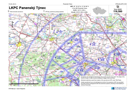
VAC chart of LKPC
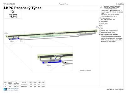
 ADC chart of LKPC
 Satellite view of LKPC

ADC chart of LKPC
Satellite view of LKPC
Sorry, we have no imagery here.
Sorry, we have no imagery here.
Sorry, we have no imagery here.
Sorry, we have no imagery here.
Sorry, we have no imagery here.
Sorry, we have no imagery here.


LKPC - Panensky Tynec
Located in Panensky Tynec, Czech Republic
ICAO - LKPC, IATA -
Data provided by AirmateGeneral information
Coordinates: N50°18'23" E13°56'6"
Elevation is 1207 feet MSL.
View others Airports in Ústí nad Labem Region
Operational data
Special qualification required
Current time UTC: 16:44:54
Current local time:
Weather at : LKPR - Praha/Ruzyne ( 32 km )
METAR: LKPR 191630Z 32010KT 9999 FEW030 BKN043 14/08 Q1018 NOSIG
TAF: TAF LKPR 191400Z 1915/2021 32013KT 9999 BKN025 BECMG 1918/1920 32004KT BKN016 TEMPO 2000/2006 4000 BR SCT008 BECMG 2012/2014 SCT040 TEMPO 2011/2018 04004KT
Communications frequencies: [VIEW]
Runways:
| RWY identifier | QFU | Length (ft) | Width (ft) | Surface | LDA (ft) |
| 09 | 86° | 8219 | 98 | ASP | |
| 27 | 266° | 8219 | 98 | ASP |
Airport contact information
Address: Panensky Tynec Czech Republic
