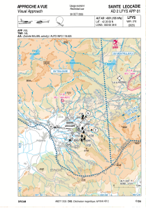
VAC chart of LFYS
 Satellite view of LFYS
Satellite view of LFYS
Sorry, we have no imagery here.
Sorry, we have no imagery here.
Sorry, we have no imagery here.
Sorry, we have no imagery here.
Sorry, we have no imagery here.
Sorry, we have no imagery here.


LFYS - Sainte Leocadie
Located in , France
ICAO - LFYS, IATA -
Data provided by AirmateGeneral information
Coordinates: N42°26'50" E2°0'39"
Elevation is 4331 feet MSL.
Magnetic variation is 1.16° East View others Airports in Languedoc-Roussillon
Operational data
Special qualification required
Current time UTC: 18:01:00
Current local time:
Weather at : LESU - Andorra-La Seu D'urgell ( 51 km )
TAF: TAF LESU 031400Z 0315/0415 VRB04KT 9999 BKN040 OVC050 TX16/0414Z TN01/0406Z PROB40 TEMPO 0315/0318 4000 RA BKN014
Communications frequencies: [VIEW]
Runways:
| RWY identifier | QFU | Length (ft) | Width (ft) | Surface | LDA (ft) |
| 07 | 70° | 2625 | 295 | GRASS | |
| 25 | 250° | 2625 | 295 | GRASS |
Airport contact information
Address: France
