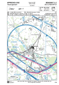
VAC chart of LFOB
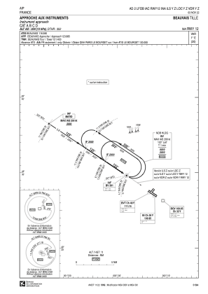
 IAC chart of LFOB
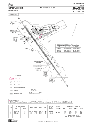
 ADC chart of LFOB
 Satellite view of LFOB

IAC chart of LFOBADC chart of LFOB
Satellite view of LFOB
Sorry, we have no imagery here.
Sorry, we have no imagery here.
Sorry, we have no imagery here.
Sorry, we have no imagery here.
Sorry, we have no imagery here.
Sorry, we have no imagery here.


LFOB - Beauvais Tille
Located in Beauvais, France
ICAO - LFOB, IATA - BVA
Data provided by AirmateGeneral information
Coordinates: N49°27'16" E2°6'46"
Elevation is 359 feet MSL.
Magnetic variation is 0.92° East View others Airports in Picardie
Operational data
Special qualification required
Current time UTC: 09:20:38
Current local time:
Weather
METAR: LFOB 230900Z AUTO 35010KT 9999 SCT045 13/03 Q1021 NOSIG
TAF: TAF AMD LFOB 230556Z 2306/2406 VRB03KT CAVOK FM230800 35010KT 9999 SCT045 BKN060 BECMG 2320/2321 VRB03KT
Communications frequencies: [VIEW]
Runways:
| RWY identifier | QFU | Length (ft) | Width (ft) | Surface | LDA (ft) |
| 04 | 41° | 2323 | 59 | ASPH | 2323 |
| 22 | 221° | 2323 | 59 | ASPH | 2323 |
| 12 | 124° | 7969 | 148 | ASPH | 7825 |
| 30 | 304° | 7969 | 148 | ASPH | 7969 |
Airport contact information
Address: Beauvais France


