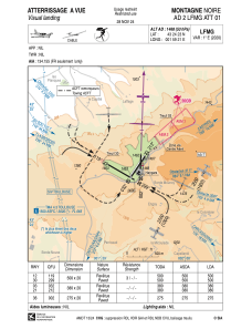
VAC chart of LFMG
 Satellite view of LFMG
Satellite view of LFMG
Sorry, we have no imagery here.
Sorry, we have no imagery here.
Sorry, we have no imagery here.
Sorry, we have no imagery here.
Sorry, we have no imagery here.
Sorry, we have no imagery here.


LFMG - Montagne Noire
Located in , France
ICAO - LFMG, IATA -
Data provided by AirmateGeneral information
Coordinates: N43°24'23" E1°59'21"
Elevation is 1468 feet MSL.
Magnetic variation is 1.13° East View others Airports in Languedoc-Roussillon
Operational data
Special qualification required
Current time UTC: 18:02:51
Current local time:
Weather at : LFCK - Castres Mazamet ( 29 km )
METAR: LFCK 031800Z AUTO 10017KT CAVOK 11/03 Q1023 TEMPO 12025G38KT
TAF: TAF LFCK 031700Z 0318/0403 12020KT CAVOK TEMPO 0318/0403 12025G38KT
Communications frequencies: [VIEW]
Runways:
| RWY identifier | QFU | Length (ft) | Width (ft) | Surface | LDA (ft) |
| 12 | 120° | 1640 | 66 | ASPH | 1640 |
| 30 | 300° | 1640 | 66 | ASPH | 1640 |
| 18 | 183° | 902 | 66 | ASPH | 902 |
| 36 | 3° | 902 | 66 | ASPH | 902 |
| 03 | 33° | 1247 | 66 | ASPH | 1247 |
| 21 | 213° | 1247 | 66 | ASPH | 1247 |
Airport contact information
Address: France
Satellite view of LFMG
Sorry, we have no imagery here.
Sorry, we have no imagery here.
Sorry, we have no imagery here.
Sorry, we have no imagery here.
Sorry, we have no imagery here.
Sorry, we have no imagery here.